The devastation in mountainous western North Carolina is almost too dire to comprehend.
— Malcolm K. Beyer, Jr. CEO
JUPITER, FL, UNITED STATES, October 23, 2024 /EINPresswire.com/ — Responding to this national Hurricane Helene disaster, volunteers have been using their knowledge and advanced military and commercial technology. There was no and still are no sources of water, food, power and phone lines or commercial internet in many places, making the coordination of getting responders and water and food in and survivors and casualties out has been especially challenging. To respond to this situation, volunteers have been working without reimbursement.
Several technology companies have been contributing their time and knowledge to assist in this rescue effort. Many are using a civilian version of the military Command and Control (CJADC2) software, LifeRing, developed by AGIS in concert with the U.S. JCS Lab in Suffolk, VA. The software integrates satellite imagery, cellular, satellite and radio communications and UAV imagery along with the locations of the Responders and enables voice, data and video communications between all.
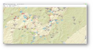
As of yesterday, as can be seen in the AGIS screenshot image, the indications of helicopter landing locations are in blue. Critical situations and impassable roads are in red, indicating that they are currently blocked, and cutting many people off from vital resources.
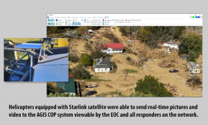
Cloud WAN Solutions (CWS) has stepped in to provide an advanced, always available and reliable network of cellular, Starlink satellite and radio communications that automatically switches over to the next best available communications option, enabling responders on the ground and in helicopters to have coordinated communications. This included modifying light helicopters to accommodate CWS communications packages.
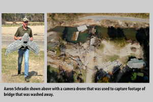
Virtual Sandtable (vST) used long duration UAVs to grab overlapping high-res images of disaster areas, thousands of acres at a time. These images were then subjected to 3D processing to produce a packaged 3D computer representation of the area that can be shared with remote teams and experts for in-depth examinations, thus enabling rapid planning of responses and efficient use of resources.
Detailed videos of the areas of destruction were obtained from CWS equipped helicopters flying in the areas of devastation. In using LifeRing software, these videos are transmitted to responders on the ground and to other helicopters and vehicles. See the LifeRing screenshot of a video taken from a helicopter of one of the affected areas being transmitted to responders, along with the location of the video in the images provided.
Maxar satellite imagery, provided by the U.S. Government, is processed to enable up-to-date knowledge of the situation. This enables the responders to know the relatively current situation of the roads and places in distress and overlay georeferenced computer symbology on the Maxar image, so that they could then attach relevant text, photographs, and video to the map symbol, thereby sharing access of the data to others and enabling them to add information to it.
For more information on these innovative rehabilitation efforts, contact:
-> AGIS, Inc., Cap Beyer, (561) 744 3213, <[email protected]>, https://www.agisinc.com/
-> Cloud WAN Solutions, LLC, Brian Clark, (336) 628 9711, <[email protected]>, https://www.cloudwansolutions.com/
-> Virtual Sandtable LLC, Aaron Schradin, (248) 343 9179, <[email protected]>, https://virtualsandtable.com/
-> Maxar, Gia DeHart, <[email protected]>, https://www.maxar.com/
To support the relief effort, consider contributing to the following organizations:
1. Flight For Life Helicopter Operations | <https://www.facebook.com/profile.php?id=61566794567842> | Flight For Life, 345 Hicks Road, Coward, SC 29530, (336) 628-9711 <https://www.gofundme.com/f/keep-flight-for-life-in-the-air-donate-now>
2. The Bethel Missionary Baptist Church in Spruce Pine, NC, 12021 S US 19E Hwy, Spruce Pine, NC 28777 https://bethelbaptistusa.com/ (828) 765-6684
ABOUT AGIS: The key personnel at Advanced Ground Information Systems, Inc. (AGIS) have worked together for many years creating military and first responder communications systems that provide data interoperability between dissimilar systems. The result is a system based on Lego type modules, enabling rapid reconfiguration to meet different requirements. The LifeRing software provides a multi-service, multinational COP to interfacing systems. AGIS, Inc., has 23 U.S. Patents, with additional Patents pending. <https://www.agisinc.com/about/>
Malcolm K. Beyer, Jr.
www.agisinc.com
+1 561-744-3213
[email protected]
LifeRing for First Responders
Legal Disclaimer:
EIN Presswire provides this news content “as is” without warranty of any kind. We do not accept any responsibility or liability
for the accuracy, content, images, videos, licenses, completeness, legality, or reliability of the information contained in this
article. If you have any complaints or copyright issues related to this article, kindly contact the author above.
![]()
Originally published at https://www.einpresswire.com/article/753761044/agis-military-technology-enables-volunteers-to-respond-to-helene-devastation


